


A non-binding explanation to the frequently asked question as to why it is not possible to determine at the touch of a button which ship has been where and when in a limited sea area such as the Baltic Sea - i.e. to carry out area-wide monitoring?
First of all, something fundamental
The Baltic Sea is not China! And under normal circumstances, there is no need to monitor everything, permanently and seamlessly! The sabotage of the Nord Stream 1 and 2 gas supply pipelines has also broken an unwritten "customary law", namely that supply lines may be threatened or influenced in an unspoken manner, but not actually attacked and destroyed.
Who is responsible for what?
The operator/owner is primarily responsible for the physical security (operational, building regulations, etc.) and structural protection (fence, wall, etc.) as well as organisational protection (mobile and static guarding, electronic monitoring support, etc.) of facilities wherever they are located. In the case of the gas supply pipelines between Russia and Germany in the Baltic Sea, for NS1 this is the company Nord Stream AG as operator - based in Zug, Switzerland. This NSAG is majority-owned by the Russian state-owned company Gazprom - which is also the owner based in St. Petersburg. NS2 is exclusively in Russian hands (operator/owner), namely Gazprom.
And when does the state intervene?
Special and unlawful incidents are recorded and investigated by state law enforcement and security authorities/organisations of the state responsible for the area concerned. This ranges from the "blue light" organisations to the armed forces, right up to the public prosecutor's offices and ultimately to the criminal prosecution authorities. It is no less complicated for the area outside territorial waters and exclusive economic zones, as international organisations are more likely to have jurisdiction here - provided that an interest in investigation and prosecution can be asserted there.
And why, pray tell, does the navy not intervene immediately?
Military security authorities and organisations (armed forces, national or allied) only come into play when they are able to counter border violations that violate international law with their presence or when they have to combat attacks with armed force. In the run-up to this, armed forces use their resources to reconnoitre (physically: above, on and below the surface; electronically: depending on the type of transmission), maintain a picture of the situation (if a valid threat requires this) and intervene (in accordance with nationally defined or internationally agreed "rules of engagement").
Have they seen nothing with all their resources?
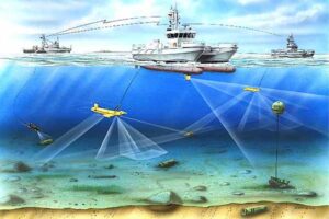
Reconnaissance above, on and under water is possible at all times, but requires increased effort and is usually only carried out in times of tension and in limited areas - each state in its territorial waters and economic zones. This requires the physical presence of naval units in the area in question, or observation from the air or from near-Earth space - i.e. by satellites. However, these cannot be everywhere and permanently, as they orbit at high speeds in order to remain stable at these distances. And if the air layers to be seen through are too full of matter (dust, sand, water vapour, etc.), then the reconnaissance results are correspondingly poor. Reconnaissance below the surface of the water is more difficult - it is only possible from above by satellite to a very limited depth - you can't see all the way to the bottom! Sensible underwater reconnaissance requires an elaborate network of special sensors, whether mobile in the form of minehunters and submarines, or stationary as a series of sonar devices laid or anchored to the bottom.
What do lighthouses and radar stations do?
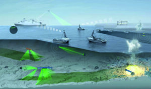
Civil maritime traffic control by traffic control centres is only carried out in particularly high-risk areas, such as narrow or intersecting fairways, canals, rivers, harbours and other protected areas, due to the personnel and technical effort involved. However, this almost exclusively covers the civilian situation picture on the water surface.
What means could be used to protect undersea infrastructure in the event of a threat?
If no static monitoring system is installed, only mobile sensor carriers can be considered for route monitoring in the short term. These primarily include vehicles operating in the "underwater" dimension, such as submarines and minesweepers/minehunting boats with downward-facing sensors installed on board and specified for the medium of water, as well as submerged, remote-controlled search drones. This also includes maritime reconnaissance aircraft with sufficient time spent in the area, which can detect magnetic field anomalies under water and pressure wave patterns on the surface, which in turn can point to submerged sources. There are also helicopters that can wave off diving sonars and "listen" underwater at different depths. As radio buoys, such sensors can also be dropped from high-flying reconnaissance aircraft.
If there are so many resources, why are they not enough?
If you add up these resources in the Baltic Sea area and divide them into a 24/7 shift service, skilfully combining air and sea vehicles, stretched over 1,200 kilometres of pipelines - some of which are not directly parallel - then you are left with something that is unlikely to be described as effective and reliable. This kind of hard work in tabular form should have been available in all headquarters around the Baltic Sea for some time now, and if the summation had provided a real, feasible answer, then such an operation would have been underway long ago. But it hasn't, at least not in a way that is recognisable from the outside, which should be seen as a negative indicator. And from the point of view of the sabotage result, no successful operation has taken place along Nord Stream - if at all. For what reason should it have taken place?
And what next?
After this incident, the considerations for Nord Stream 1 and 2 are completely superfluous! However, they are all the more necessary for the other energy and information networks in the Baltic Sea and beyond, especially in the North Sea, where there is an even more complex network on the seabed - with long distances and large areas!
What does all this tell us?
If a plant operator/owner cannot or does not want to secure its plants and the (dependent) recipient state does not see any need for special protective measures in terms of energy/security policy, then there is no political or military mandate. Surveillance of such installations is only carried out - if at all - on an occasional basis, i.e. when travelling through/over a designated area.
In other words
In the Nord Stream case, each neighbouring state is now searching its own and allied data storage facilities to see what ship movements and suspicious sensor recordings can be found there in order to then jointly reconstruct whether a pattern can be identified! This is time-consuming and painstaking detective work and forensic forensics - quick results are not to be expected.
In terms of functioning energy pipelines and underwater information networks, all other resources will now be able to focus on protecting these facilities in a targeted and coordinated manner - both nationally and internationally - provided that this is politically desirable and the appropriate security organisation is in place. However, the recent horror should have helped to bring about a general realisation. Since all but one of the countries bordering the Baltic and North Sea will soon be members of the alliance, it should be possible to coordinate across these marginal seas "barrier-free" and on a large scale. But even then, resources are scarce - and 1001TP3 security is an illusion!
These are just a few thoughts on the question: Why isn't ... didn't ... wasn't ...? ?
Axel Stephenson
KptzS (retired)


3 responses
Maritime security suddenly takes centre stage - Where is the German Coast Guard?
The navy may only "intervene" in the event of war. In peacetime, the civilian services are responsible. At most, the navy can provide administrative assistance to the civilian services.
What risks/threats exist in the territorial sea and in the economic zone?
- Maritime safety
- Offshore wind farms, offshore platforms for oil and gas
- Pipelines for gas and oil, power cables, submarine cables
- Terminals for LNG, oil, cruise ships
- Coastal defence structures, dikes
- Spontaneous natural disasters, major accidents
- Ammunition waste
- Sabotage, terror and piracy, crime.
How prepared is Germany for this?
There are around 15 different federal and state responsibilities for 40,000 km2 of German sea areas:
- Federal Police Sea
- Federal Customs Sea
- Federal fisheries control
- Federal Waterways and Shipping Administration
- 5 water police + fisheries services from 5 coastal states
- Havariekommando Cuxhaven as a joint organisation
- also DGzRS and Navy
There is no efficient, intervention-capable and professional centralised German Coast Guard. Since 1949, all proposals in this regard have been rejected by the respective authorities and parliaments,
regrets not only Uwe Jenisch, Kiel
Following FKpt Meißel, General Dwight D. Eisenhower is to be quoted:
Failing to plan is planning to fail.
Be prepared, yes.
Thank you for the clarifications, which seem necessary in view of the questions cited. Nevertheless, from my point of view, it should be noted that "don't do that" seems to be a rather futile and hopeful approach in today's conflicts. On the contrary, this is probably countered by "everything is permitted in war and love", which new-fangled despots obviously prefer to anticipate. It can only follow that we should be better prepared for the unexpected... or to quote Murphy's set: if something can go wrong - it will go wrong!!! So better: ne prepared!